National Wetlands, Nayarit — The Río San Mezquital basin is the principle source of fresh water in this coastal zone. It is essential in maintaining the balance within the complex local ecosystems. But today, its vital environmental role is being threatened by the proposed Las Cruces Dam.
"The Federal Electric Commis-
sion wants to put in a hydroelectric dam, they're campaigning for it, which has us really worried," said Julio Mata Ceja, restaurateur, tourist service provider, fisherman, and oyster farmer at the Toromocho ejido, south of the vast National Wetlands.
As if that were not enough, these wetlands, which are internationally recognized for their environmental importance, are further threatened by two
years caused by the containment barrier built on the Santiago River at Aguamilpa. The project prevents nutrients, soils and water from reaching the southern part of the wetlands. Furthermore, it has kept the historic annual floods from reaching the delta. Such floods are vital for the protection of beaches and without them the rate of erosion along the Pacific Coast has increased to 16 meters per year.
Nayarit
11
Likewise, the fishermen from the estuaries contend daily with all of the ills afflicting large coastal wetlands throughout the world: alterations in the balance of fresh and salt waters; the interruption of migratory patterns of species that once reached the mountainous interior due to the building of poorly-conceived infrastructure projects (from dams to highways); the invasion of non-indigenous exotic species; deforestation; changes in land use (often with accompanying in-
Camichín-Mexcaltitlán." Less sediment also means less productive ecosystems. "Building the dam would be the height of insensitivity," warns Mr. Blanco.
The subject of the Las Cruces hydroelectric dam undertaking goes hand-in-hand with two other large dam projects in Sinaloa: the Picachos Dam on the Presidio River and the Santa María Dam on the Baluarte River. These projects are aimed at opening a new agricultural irrigation district next to the swamps of Hizache Caimanero, which is in the northern reaches of the wetlands.
This interwoven complex of water works demonstrates the disconnect in the discourse and strategies that exists between the official environmental sector and the rest of the governmental policy makers. Furthermore, they intend to go forward with the Escuinapa Pacific Coast tourist mega project and complete two
Coastal Wetlands At Risk
Three new dams, along with highways and
mega development projects, are placing the
survival of
coastal wetlands at risk.
By Agustín del Castillo*
creased rates of erosion); the overexploitation of natural resources for agricultural pur-
poses; agrochemical contamin-
ation; the release of untreated waste water; and lastly, garbage.
In May of 2010 the protection of the National Wetlands Biosphere Reserve was decreed, setting aside 133,854 hectares (330,760 acres) in the State of Nayarit. The reserve contains the most extensive mangroves on the Pacific Coast of Mexico and accounts for 20 percent of the nation's total. It is anticipated that another forty thousand hectares (98,800 acres) of Sinaloa's wetlands will be added to the reserve sometime in 2011.
While announcing this, Victor Hugo Vázquez Moran, the director the reserve and a member of the National Com-
mission for Protected Natural Areas (CONANP), indicated the emergence of a local movement whose objective is the recuper-
ation of the conditions that allowed the region to flourish for centuries. The ejidos already care for their mangroves and have established groups that watch over the sensitive areas and guard against violations, encroachments and even the poaching of wild animals, says Mr. Vázquez, "because they have learned that their primary means of subsistence—fishing —depends on the health of their regional eco-
systems."
CONANP has agreed to study and analyze the situation at Las Cruces once it is open to formal debate. There have not been any environmental impact studies to date. Nevertheless, the special mission of the Ramsar Conventionion on Wetlands of International Importance has already initiated the debate, having been invited to participate by the Mexican government in August of 2010.
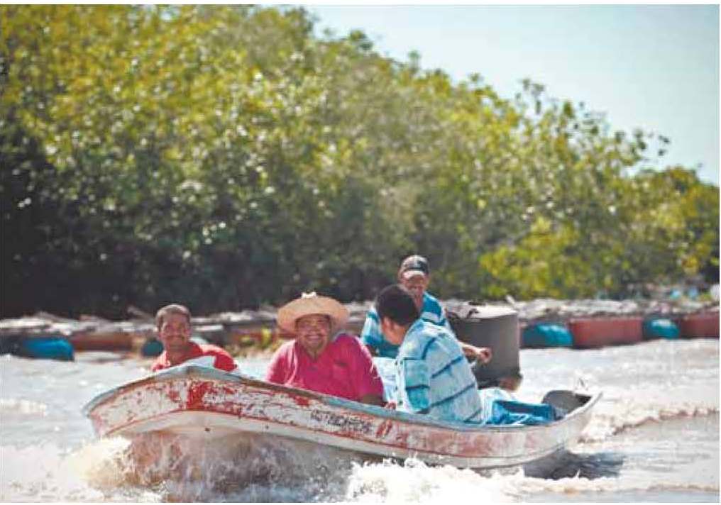 Fishermen are those most directly affected by the damages inflicted on wetlands. (Photo: Marco Vargas)
other dams, several regional highways and the tourist mega project known as the Pacific Coast Integrally Planned Center.
The rural inhabitants from all of the wetlands have attended a series of meetings with others who have been similarly impacted by dams throughout the country, and are seeking to establish mutually supportive strategies in the event that attempts are made to force the mega development projects on them. The most recent meeting was held in early December 2010 in Cancún, Quintana Roo with the objective of bringing inter-
national attention to their cause during the UN-sponsored World Conference on Climatic Change.
The rural inhabitants of Nayarit base their opposition to the projects on the disastrous consequences of the last 20
ited, except in cases where such projects are designed to restore the water's natural circulation and thereby promote the regeneration of coastal wet-
lands."
Manuel Blanco, an investigator from the Autonomous Uni-
sity of Nayarit, sees the Las Cruces project as the death knell for the National Wetlands. "Undoubtedly, the hydroelectric dam will retain all of the bottom sediments, causing an effect similar to the coastal erosion that has been caused by Aguamilpa (…). But in the interior coastal lagoons, in addition to altering the hydrological cycle in the heart of the wetlands, the alteration of the cycle of sedimentary deposits would also impact historic alluvial and estuarine patterns and cause destructive erosion problems similar to those seen along the coast, especially in the tidal troughs at Agua Brava and
National Wetlands provide hope for sustainable production of primary resources, the recovery of protected species like jaguars and river crocodiles, and the conservation of beaches used for nesting by the Olive Ridley sea turtle and over four hundred different bird species.
In the meantime, the region's inhabitants aren't sitting still while the plans for Las Cruces and related projects--plans drawn up far removed from where they will be implemented--go into effect. They find their answers in one or another official, like the ejido’s President María Guad-
alupe Medina López, from Palma Grande in the municipality of Tuxpan, Nayarit, who says "All of the villages are joining forces to keep it from happening."
This is an extract from a series of articles on the National Wet
lands, courtesy of the newspaper Público of Guadalajara.
* Winner of the 2010 Walter Reuter Journalism Award and the Reuters-IUCN 2008 Regional Award for Excellence in Environmental Journalism.
environmental impact of these engineering projects has led to the loss of thirty thousand hectares (74,000 acres) of natural vegetation in forty years and it's estimated that another ten thousand hectares (24,700 acres) have been consumed by the sea.
Given this reality, it is no wonder that 30 percent of those who have been born in the region now reside in California, USA, principally in San Diego. These new mega projects will likely lead to a repeat of the experience, a nightmare situation that could end up destroying the already-precarious way of life in the area.
Even so, the mangroves and coastal wetlands are still prized for their roles in the reproduction of fish of high nutritional and economic value. They also serve as buffer zones for hurricanes, they capture water and carbon and they provide a habitat for many endangered species. The
major highways to connect the east (Monterrey-Durango) and center (Mexico City-Tepic) of the nation with a zone that has remained relatively intact until now precisely because it has never been easy to reach.
Since the 1950s the shorelines of the coastal wetlands of both Nayarit and Sinaloa have been occupied and placed into production, agricultural rights to the mangroves and waters have been distributed, almost all of the region's crocodiles have been killed and jaguars have been hunted down, the Cuautla Channel was opened, shrimp shrimp farms have been established in the area, the Aguamilpa Dam was built, and tens of thousands of hectares of land have been cleared of their natural vegetation, specifically mangroves and low jungle foliage. Furthermore, many mangroves were unable to survive the dramatic environ- mental changes. The severe
The site of the proposed hydroelectric dam is near the communities of San Pedro Ixcatán and San Juan Corapán, on the access road to the Sierra Los Coras. If built, it will inundate 4,547 hectares (11,236 acres) and require the relocation of the people of San Blasito, a community of 100 inhabitants. Additionally, the completed dam would affect five other Nayeris or mestizo villages.
Findings of the Ramsar group highlight the low public participation in the decision-making process and the lack of consideration of the accumu-
lative effects of distinct projects. Although it does not reach a conclusion, the report mentions the Mexican environmental law NOM-022-SEMARNAT-2003: "Any project that channels, interrupts or re-directs water and places in danger the dynamics and integrity of the ecology of the coastal wetlands shall be prohib-