 Located north of Guaymas on the road to Hermosillo, the Sierra del Aguaje, is the perfect place to rest and reflect.
 On Friday, March 19, 2010 a small group of nature lovers set out on an adventure, their goal to get to know a little more about the natural treasures to be discovered in the Sierra del Aguaje. They returned to the city the next day; they would never be the same.
The first stage of the trip was from the port city of Guaymas into the mountains where they set up their camp and a fire to prepare their meal. While eating, they shared their perspectives about the area. After spending the night in an open campsite, they walked and climbed through the desert until they found a small oasis—permanent natural springs—known in Mexico as an aguaje or watering hole.
“It was something completely different than what I’d had in mind when I left home,” one of the ten hikers said. “As we got to know every little corner of the area we were exploring, I came to realize that simple things, like the cricket’s song, the wind that caresses your face or the trees that shelter you at nightfall are the things that really matter,” he said. “It was an unforgettable experience.”
Getting There
They met and set out in their vehicles at 2:30 on Friday afternoon. In a small caravan, they left Guaymas and headed towards the capital Hermosillo, turning off of the international highway just before the El Tigre bridge. Heading west on a dirt road, they crossed the desert through desert scrub and cacti.
They crossed a dry stream filled with white flowers then passed by a homestead with only a roofless brick house and a leafy tree. They found a handful of cows and bulls as well as a barking dachshund but no sign of people.
Farther along they saw other dry washes, the marks left behind by the storm season, and a diversity of plants. At about halfway into their journey, from a distance they were treated with a view of Las Pirinolas, a geologic formation of sharply pointed mountains which gets its name from its resemblance to a candy of the same name. Just like the candy, the peaks have a pointed but truncated pyramidal shape.
Camping
They soon arrived at a clearing off to the side of the side of the dirt road where they established their camp. After collecting firewood and setting up the tents, they made quesadillas and toasted marshmallows over their campfire. Gathered around the fire, each spoke of his or her expectations for the hike the following day.
They took in the starry sky and the moon, which was close to the planet Venus. As they watched, the celestial bodies slowly disappeared, one after the other with the rotation of the Earth -- first Venus and then the Moon slipped behind the horizon.
The pre-dawn temperatures had them looking for more firewood to take away the chill and to later prepare a breakfast of eggs and chilorio. Fortified, the group set out along the bed of the Cañón de los Anegados, excited about what might await them along the path.
With the sun at one’s back, dreams lie ahead
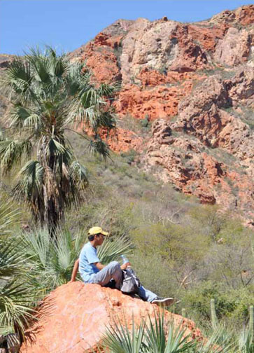
The canyon instilled a sense of calm with its silent, 32 ft high walls, its white sandy bottom speckled with colored rocks and on all sides a wide variety of both tropical and desert plants.
Walking along they could see that the path continued all the way to the Gulf of California, but long before that they turned towards the mountains with the idea of reaching Aguaje Robinson. They passed by what looked like a corral and a house, after which they began to climb.
The first part of the ascent was easy because the ground was hard and firm. But higher up where the hillside was steeper, it soon became soft and slippery. Cables tied between palm trees at the side of the trail helped in the climb.
At the bottom of the grade they had seen a storage barrel that they later discovered was fed by an even larger tank. This in turn was being filled by a hose that led from the water’s source, the aguaje.
Aguaje Robinson past and present
The history of El Aguaje Robinson (Robinson Springs) tells of a time long past when its waters reached the foot of the mountain. However, one day somebody held back its flow. It will never be known if that
Located north of Guaymas on the road to Hermosillo, the Sierra del Aguaje, is the perfect place to rest and reflect. was the reason why an entire family was found murdered there, but this much is known: these springs and others in the area were of great importance to the ancestors of the indigenous Seri as well as other local inhabitants. Evidence throughout the desert region indicates the presence of both temporary and permanent dwelling sites nearby the streams fed by such natural springs.
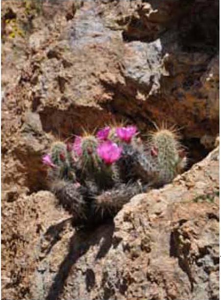
Today, this zone continues to be important due to the wide diversity of plants and animals that differs from other parts of the state. The canyons of the Sierra del Aguaje have vegetation typical of the tropics, such as palms, while also harboring desert plants such as mesquite trees and cacti like pitaya and saguaro.
The fauna of the region is also very diverse, with a wide variety of insects and fish at the coast, including 14 species endemic to the Gulf of California, as well as many other species of birds, reptiles, and amphibians.